If you recall my last article, we discussed the aspects of using radio phraseology and talking on the radio in relation to simulation.
In this article, we’ll continue delving deeper into the web of radio usage and terminology. Most of what I will be referring to will be directly out of the Airman’s Information Manual (AIM), Section 2. Radio Communications Phraseology and Techniques, 4-2-1.
My last article was fun, it was a challenge to write and fun to discuss simulator communications. This takes that foundation a step further and will start to introduce the reader into the practical knowledge and operation of how pilots and controllers use the radio in real operations. There are two important caveats to note before we go any further:
- Although there are many similarities, ICAO (other than United States) follows different procedures and practices – but they are similar enough that a good understanding of FAA procedures will provide a good over-view.
- This article is written as an aid to flight simulation and not intended as a replacement for flight instruction. In reality, communications with Air Traffic Control (ATC) is regulated and dependent upon a pilot’s legal obligation to follow the regulations inherent in the airspace of which they operate. We will not discuss regulations too closely so rated-pilots will notice gaps in information. This is to both make the article shorter but also less dry and maintain focus to the target audience – simulator pilots.
So how do helicopters operate within the national airspace? Generally speaking, helicopters operate in the national airspace in a very similar manner to fixed-wing aircraft. Where helicopters really differ is that they are a unique aircraft with considerations that airplanes do not necessarily have; essentially, we can hover. The AIM addresses this specifically:
4-3-17. VFR Helicopter Operations at Controlled Airports.
- The following ATC procedures and phraseologies recognize the unique capabilities of helicopters and were developed to improve service to all users. Helicopter design characteristics and user needs often require operations from movement areas and non-movement areas within the airport boundary. (Abbreviated)
- Insofar as possible, helicopter operations will be instructed to avoid the flow of fixed-wing aircraft to minimize overall delays; (abbreviated)
- Helicopter pilots are intimately familiar with the effects of rotor down wash, they are best qualified to determine if a given operation can be conducted safely. (Abbreviated – What these addresses is that it is incumbent upon the helicopter pilot to conduct operations safely in regards to directional control and avoiding other traffic).
Definitions:
- Hover Taxi: Slow forward movement is desired or when it may be appropriate to move short distances. If operating above 25 feet AGL or greater than ETL when hover taxiing, the pilot should initiate a request to ATC.
- Air Taxi: The preferred method for helicopter ground movements on airports provided ground operations and conditions permit. Air Taxiing is done greater than ETL and less than 100 feet. Unless otherwise requested or instructed, pilots are expected to remain below 100 feet AGL. Helicopters should avoid overflight of other aircraft, vehicles, and personnel during air-taxi operations.
Takeoff and Landing Procedures
Helicopter operations may be conducted from a runway, taxiway, portion of a landing strip, or any clear area of which could be used as a landing site such as the scene of an accident, a construction site, or the roof of a building.
The general nature of this regulation is to enable helicopter operations/ATC to utilize best discretion in order to conduct operations and avoid the flow of fixed-wing traffic. The regulation meant to be permissive in use and not prohibitive.
In most operations, helicopter departures may be in areas not visible to the tower. In which case, ATC will advise that “Departure will be at own risk,” this isn’t meant to be scary.
This is simply stating that ATC is clearing the aircraft for the request but cannot see potential hazards, obstacles or traffic that could endanger personnel or aircraft and they expect the pilot to operate the aircraft in such a way as to conduct the maneuver safely. In these instances, pilots should be especially vigilant for other aircraft and vehicles operating in and around the airport.
Therefore, it’s good practice for the helicopter pilot to verify runway crossing instructions and if unclear, hold short of runways or active taxi-ways where there is an increased risk of an aircraft collision. This is especially important prior to crossing extended runway center-lines!
In most instances, it’s a lot easier for a helicopter to get out of the way of a fixed-wing airplane than the other way around. In no instance should the helicopter pilot take-off and fly through an extended runway centerline without first confirming that they are cleared to do so.
Airspace
Many of the popular airports that simulator pilots visit exist within some form of airspace. Depending on which class of airspace the airport is in, there may be specific communication requirements that pilots must adhere to.
Sometimes, a helicopter may wish to operate to and from a heliport or helipad that lies within that specific class of airspace. As some of you may know, most airspace in the United States and in some European countries are visually depicted as an upside-down wedding cake where the airport is located in the center of the top-most tier.
In most instances, we may operate easily under the shelf of the airspace without talking to anyone although, it’s prudent to monitor the controlling frequency for that airport. Yet, in some instances, we may need to operate within that section of airspace (example, landing at a hospital). This is where knowing which airspace you’re in and what the communication requirements are, is important.
In the United States, we have six classes of airspace. For the purposes of this article, I won’t detail special use airspace’s or weather requirements, I’ll just discuss how it pertains to airport operations.
- Class A Airspace: Airspace that extends from 18,000 feet up to 60,000. Because of the speed and altitude of aircraft operating in this airspace, it requires an Instrument Flight Rules (IFR) clearance and ATC communication. (This is usually much higher than the average helicopter pilot will find him or herself).
- Class B Airspace: Generally, that airspace from the surface to 10,000 feet surrounding the nation’s busiest airports (JFK, SFO, LAX, SEA). Each Class B Airspace is individually tailored to the airport it services and consists of a surface area and two more layers (upside down wedding cake). ATC clearance is required to operate within the airspace and the aircraft must have a mode C transponder (altitude encoding equipment) operating within 30 nautical miles. These airports are VERY busy and congested. A lost pilot wandering into the approach path of several airliners during rush hour will very quickly discover that the FAA frowns upon this and will likely have their piloting privileges revoked.
- Class C: From the Surface put to 4,000 feet above Mean Sea Level (MSL). Although each airspace is individually configured, its generally a five nautical mile ring around the airport and may include a ten nautical mile “shelf region” that extends no lower than 1,200 feet (extending up to 4,000 feet). Again, to operate within the airspace itself, two-way radio communication with ATC and a mode C transponder must be utilized.
- Class D: Typically, a single circle around the airport which may be individually tailored (typically 4-5 miles depending on the facility) and extending up to 2,500 feet MSL. This is the last class of airspace that will have a control tower (although, exceptions exist). Only two-way radio communication is required to operate within class D airspace.
- Class E: This airspace serves to function as a means for ATC to handle IFR traffic. Class E airspace generally extends from 1,200 feet MSL up to 18,000 feet. In some instances, class E airspace may extend down to 700 feet above ground level (AGL) to accommodate instrument approaches into servicing airports. Class E Airspace does not require radio communication unless operating under an ATC clearance.
- Class G: This, and in some instances, class E, is the airspace that most helicopters operate within. It is that airspace that extends from the surface up to 700 feet AGL and is uncontrolled. Generally, it is not required for a pilot to talk to anyone or have any special equipment to operate within Class G Airspace.
Now that we’ve covered the basic knowledge we can really start to delve into the meat and potato’s of using the radio and why it’s important. Aviation is a precarious profession.
Often, there are hundreds of aircraft and thousands of passengers transiting through very small and congested corridors in short spans of time. Any look at the arrival and departure schedules at your local airport will prove that many patterns start to emerge and recur continually.
The system is designed as such that everything flows almost seamlessly and without incident. When you consider how many thousands of tons of luggage is shifted alone at an airport in a single day, you really start to gain an appreciation for every member of the air transport industry; the machine runs off communication.
When you combine human error, weather, complex mechanical machines and logistics, then the environment really starts to look pretty precarious. But it works so well because of communication. The ability for controllers to communicate with pilots, follow regulation and procedure and manage expectation is paramount.
The very first exposure the new pilot has to this dance is the basic traffic pattern. Not only is this where the student pilot spends most of their time, but it’s also where they quickly learn that controllers really have a tough job to manage and that flying really is an orchestration in balance. Traffic patterns establish a set expectation so that controllers can quickly locate, identify and vector traffic to maintain legal, yes, legal traffic separation and control. The graphic below is a normal traffic pattern:
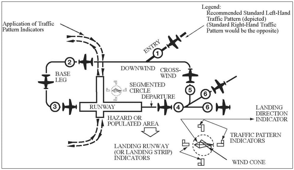
It’s important to note that at busy airports, traffic patterns are often employed as part of a larger schematic and do not look like this. Airlines and passengers would get pretty frustrated being sequenced in this type of pattern as it would take up copious amounts of time and fuel.
At airports like Los Angles International, smaller traffic is typically not permitted without consent and prior coordination from the ATC facility.
How does all this pertain to helicopter flight? In several circumstances actually! Helicopters can and do, file IFR flight plans, in which case they are expected to follow the same procedures as fixed-wing traffic.
But also, understanding the basics of a traffic pattern enable us to avoid the flow of fixed wing traffic because often, helicopters do not follow the above pattern.
Due to the unique operating principles of helicopters, often they don’t find themselves stuck in a traffic pattern unless for specific training. During normal, day-to-day operations, air traffic control expects helicopters to request and accept point-to-point transitions.
But who do we talk too?
Please, trust me: this will be an article about talking on the radio at some point and I’m by no means trying to insult anyone’s intelligence – but these articles are written for the brand-new beginner all the way up to the veteran simmers so I need to lay the ground work to ensure that a good basis of knowledge is provided before we get into the good stuff.
Within the United States, there are many entities that make up the air traffic control structure. Most common is “Tower” and everyone who has been around aviation some capacity understands that there is usually an Air Traffic control tower and that there must be some form of contact between them and an aircraft.
Although in reality, the air traffic control structure is much larger than just an air traffic control tower and through the course of a flight, a typical pilot can find themselves talking to many different agencies whom inter-communicate to ensure that a flight is handled from start-up, taxi, take-off, enroute and landing.
Air Route Traffic Control Center (ARTCC) – or “Center”: These are the folks that own a majority chunk of the airspace from the base of the underlying airspace all the way up to 60,000 feet and can span hundreds of miles. Most centers primarily handle airline traffic.
Terminal Radar Approach Control (TRACON): Typically serves a specific airport. These folks work from 17,000 feet down and within 50 nautical miles of the servicing airport. They are your approach and departure control people that most traffic is handed off to once an aircraft has left an airport’s airspace.
Control Tower: These are the people that most pilots are familiar talking with. They comprise the staffing to handle ground control and clearance departure. They sequence the flow of traffic in and around an airport and issue clearances for taxiing, take-off and landing. Small airports usually staff 4-5 people and larger airports can have as many as fifteen controllers working the airspace.
Flight Service Station (FSS): The name says it all – services! FSS’s are usually a pilot’s best friend after they’ve departed an airport. These folks are not necessarily stationed at an airport at all. They staff facilities that are responsible for providing pilot briefings, enroute communications, assist lost aircraft, relay ATC clearances and can notify VFR search and rescue should a flight be over-due. They can also notify pilots of bad weather and enroute flight advisories.
Really quickly, let’s go to a soccer game. We’re going to leave our house and drive to the stadium some 50 miles (or kilometers) away. So, we pull up Google Maps to get directions (Google maps is our ARTCC, providing long distance guidance on how to get to the stadium).
While driving to the stadium, our friend calls us and notifies us that the traffic getting into the city is really congested and suggests a different route (that’s FSS). Once we get close to the stadium, traffic Marshall’s in high visibility jackets direct us to the correct parking garage (that’s TRACON).
And, finally, as we pull into the parking garage, we pay the garage attendant and he tells us where to park (Tower).
Operating at Airports without a Control Tower
Many airports that helicopters operate out of, including heliports, helipads and grass airstrips may have no control tower or part-time control towers. There are three primary methods for pilots to operate out of these facilities.
A pilot may utilize a Flight Service Station (if its on the airport), a UNICOM frequency or a self-announce broadcast. Most simulator pilots will have to use a self-announce broadcast for airports with no control tower.
When planning your flight, it’s imperative to review the information for the airport your flying out of and into. The frequencies and operating times of the control tower (if available) is printed on the aviation sectional chart or in the airport/facility director.
The acronym CTAF or “Common Traffic Advisory Frequency” is designated for operating at un-towered airports or at airports where the tower has closed for the day.
Pilots operating to and from an airfield should monitor and transmit their location and intentions on the CTAF when operating within 10 nautical miles to the airport. Aircraft on the ground should announce startup, taxiing and intentions at non-towered airports.
Example: Costa Traffic, Jetranger 456ES, (position) Hoover Dam, one-thousand feet, descending to five hundred feet, entering the downwind for runway 9, Costa.”
After landing, aircraft should announce when they’re clear of the runway and where they cleared the runway at.
“Costa traffic, Jetranger 456ES clear of runway 9 at bravo taxi-way, Costa”
Departing non-towered airspace:
“Costa traffic, Jetranger 456ES taxiing to Runway 9, Costa” (continued) “Costa traffic, Jetranger 456ES departing runway 9, departing the pattern to the east, climbing one-thousand feet, Costa.”
Non-towered airports follow this set format to ensure that all pilots have the same expectation and formulate a community of responsibility and mutual understanding.
Operating at Airports with a Control Tower
The beauty of understanding how a CTAF frequency works is that most of that same information applies to towered airports. The primary difference is that now, instead of de-conflicting with other pilots, a pilot simply calls the control tower and tower provides directions based from traffic flow.
The same basic tenants of talking on a CTAF still apply with talking to a controller except for the controller is responsible for traffic separation. But beware, controllers are humans and sometimes they make mistakes and mis-identify aircraft; therefore, it is still incumbent on the pilot in command to ensure the safe and successful operation of their aircraft – even if that means deviating from a controller’s instructions or answering with “cannot comply”.
Prior to contacting air traffic control or the airport tower for instructions, its best if the pilot familiarizes themselves with the basic information of the airport. Most pilots refer to an Airport/Facility Director (A/FD) which is published by the FAA to derive this information.
Although, there are many great free resources online that will help supplement the simulator pilot. SkyVector is one such resource where you can not only construct flight plans, view airspace but also view airport diagrams.
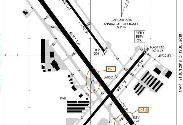
Additionally, a lot of useful information can be derived from A/FD’s and airport diagrams. The region name and airport name, ICAO are contained in the header and footer information along with the version of the diagram.
Valid dates of use are along the right and left edges and then along the top includes the ATIS, Tower and Ground control frequencies in both VHF and UHF (if available). The circled regions (HS 1, HS 2) are “hot spots” where traffic can become congested or confusing and particular vigilance must be exercised.
Through Flight
From this point, I’ll run through a basic flight and how a real pilot would typically conduct operations so that you can see how it’s done.
For ease of instruction, this will be a VFR flight and not include any flight plans or extraneous information. In later articles, IFR flight plans and operations at larger airports will be included. I’ve included the basic information pulled from SkyVector so that you may visualize the route and so that we can discuss the information that will be necessary to complete this flight.
With the exceptions of certain missions or operators, most helicopter flights are not conducted using instrument flight plans or under IFR conditions so the situation we will review is pretty common. Please remember, this is for simulation purposes and is simplified for simulator usage.
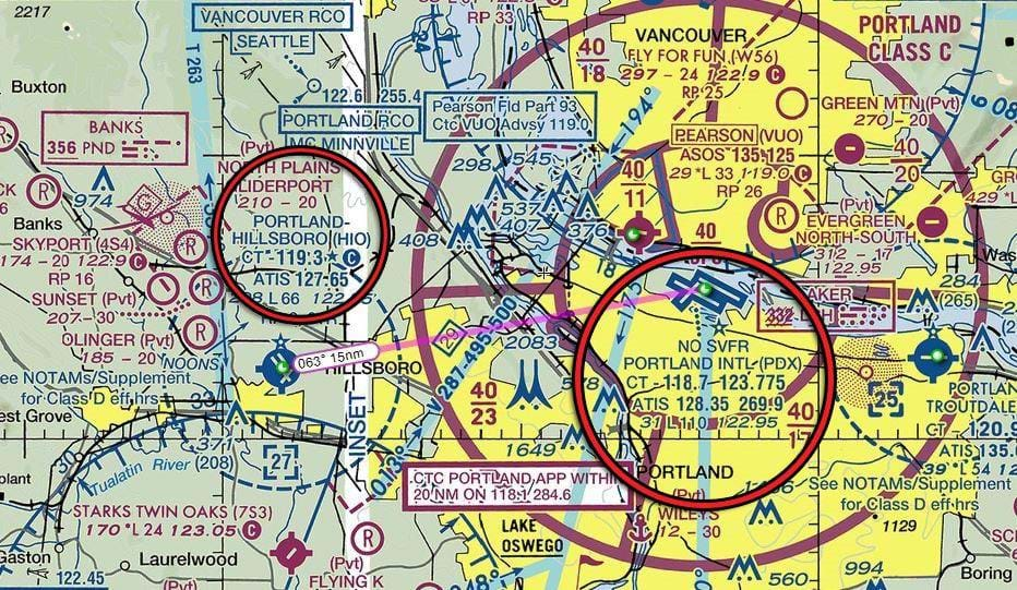
Today we will be departing Portland-Hillsboro, HIO and conducting a VFR flight from Hillsboro, KHIO to KPDX, Portland International.
The route of flight is 063 degrees for 15 nautical miles and will take approximately 8 minutes at 110 knots. We can derive, based on the sectional above and from reviewing the airport diagrams, that our departing tower frequency (CT) for HIO is 119.30 and that the tower frequency for PDX is 118.7 or 123.775 depending on which runway we are instructed to use.
Additionally, PDX is a C Class airport so we too must contact Portland approach within 20 nautical miles as indicated on the VFR Sectional Chart.
Here too is a good example of airspace that is tailored to conform to other airspace surrounding it. The solid magenta lines surrounding PDX indicates its airspace and the numerals within describe the airspace floor and ceiling.
 The outer rings are divided into sections. Each “slice” has its own numeric to describe floor and ceiling limits. Should we be between those altitudes, it is required we are talking to air traffic control. In this instance, the floor is 1,800 feet and the ceiling is 4,000 feet.
We’ll be launching from the Hillsboro Aviation Ramp which is situated on the South east corner, near the departure end of runway 31L. Like most airports with areas specifically designed for helicopters, the ramp we’ll be taking off from is within the non-movement area.
Each airport is a little different – with larger airports, or airports with pads specifically designed for helicopter take-off and landing, they might require you to contact ground to request hover taxi. In smaller airports or airports where the helicopter flight line doesn’t have a specific pad or launches from that parking area, you might be just contacting tower directly.
At Hillsboro, the pilots usually pick up to a hover, taxi to the grass just east of the parking and then contact tower. After a thorough pre-flight and start-up, we first tune-up Automatic Terminal Information Service (ATIS) on 127.65 and hear a weather briefing.
ATIS: “Hillsboro information Sierra. 1300 Zulu
Weather, ceiling three thousand overcast. Visibility 10. Temperature six eight. Dewpoint four three. Wind three five zero at eight. Altimeter two niner-niner two. ILS runway one-three right approach in use.
Landing runway three-one left and three-one right, departure runway three one. Advise you have information sierra.”
And it continues on a loop. That gave us the basic information we require for take-off from Hillsboro, currently information current as of 1300 Zulu is Sierra.
As the day progresses, each time the ATIS is updated, it is assigned an alpha code. Sometimes, this is hourly or more frequent as weather changes. When you contact ground or tower (whichever is first) you will advise them that you have “Information Sierra.”.
Then, the weather statement: Ceilings are 3,000 feet overcast, visibility is 10 miles. Temperature is 68 degrees Fahrenheit and dew point is 43. The altimeter setting is 29.92 and runways 13R Instrument landing system is in use but typically, traffic is using 31L and 31R. Again, its information Sierra.
We note down “S” on our knee board for Sierra and also the winds and altimeter setting. Then tune up tower on 119.30. After hovering into position for take-off, we conduct a clearing turn for traffic and then, we time our request as not to step on other traffic that may be transmitting and hail tower.
“Hillsboro Tower, Jetranger 407 Hotel Sierra (our tail number) is East sod with Sierra, requesting a present position departure to the north,”
Tower may be busy, and they may need to issue instructions to other aircraft or tell you to “Standby,” just be patient and only transmit again if you’ve waited a long time or there is a dangerous situation. In this case, it’s a slow day at Hillsboro (rare) so they respond to use quickly.
Tower: “Jetranger 407 Hotel Sierra, cleared take-off to the north, remain at or below 700 feet, notify when clear of the Hillsboro class Delta airspace. Safe flight.”
That’s a pretty straight forward instruction. So, we confirm it back to tower.
“407 Hotel Sierra cleared for take-off to the north, at or below 700 feet, we’ll notify clear.”
You’ll hear some pilots “spice up” their radio calls by saying phrases such as “On the go” or short-handing transmissions even further. Although in some instances, short-hand is required, often, its utilized incorrectly and just leads to confusion.
What may sound cool, might just be frustrating or time consuming for other traffic and the controller. Often, full read back of a clearance and professionalism is the best method.
We continue our climb out and clear the class Delta airspace – pop quiz, how far out is the airspace? Four nautical miles, good answer. So, we send a quick transmission to Hillsboro Tower,
“Hillsboro Tower, Jetranger 407 Hotel Sierra is clear of the Class Delta to the North, have a good day.”
Tower: “Jetranger 407 Hotel Sierra, frequency change approved, have a good flight.”
Although the chart specifically indicates that as long as we remain below 2,300 feet on our present course, we do not need to contact approach control (TRACON) until we are within five nautical miles to the airport, the chart specifically asks us to and it might assist approach control with sequencing our aircraft into the flow of traffic.
In any instance where we can help those folks with traffic management, its usually in our best interest and safety and might speed up our admittance to the airspace (remember, they have to clear you into airspace within that five nautical mile ring). First, we tune up Portland ATIS on 128.35 and listen to the weather – for the sake of the article we’ll say the weather is the same and the information Sierra is current.
We tune the correct approach frequency, 118.1 into our primary radio and then Portland tower, 118.7 into our secondary, standby frequency. Then call Portland:
“Portland Approach, Jetranger 407 Hotel Sierra is 10 nautical miles to the south east, 1,500 feet with information Sierra for Portland, to land.” What we’ve told them is our:
- Present position
- Altitude
- Information
- Destination
- Intentions
This will help take the guess work out of the controller’s job. From this information not only can he or she find us on the radar screen but he or she also knows where we’re going and what we want to do.
Additionally, we’ve added that we have information Sierra for the airport we’re going to. He or she now also understands that we’re familiar with the airport condition and which runways are in use. Approach controllers are very busy and also sequencing much faster traffic so keeping this transmission short and sweet is the best course of action.
From here, the controller may ask us to remain clear of the class Charlie airspace or to continue and anticipate a frequency change to tower.
“Jetranger 407 Hotel Sierra, Portland Approach, radar contact, remain VFR, expect vectors to final.”
There are several ways approach may respond to an aircraft that has contacted them. They may state that they have radar contact, that they may not have radar contact with you, or request that you “squawk” and “ident” a code on the transponder (which is typically set to 1200 for VFR by default). They may also ask you to clarify your intentions if they require more information,
Approach: “Bell 407 hotel sierra, state intentions.”
“Portland Approach, Bell 407 Hotel Sierra for General Aviation parking at Portland,”
Additionally, if they are busy, they may not respond with your tail number and ask you to standby – this indicates that they are aware you called but may too busy to honor your request and at which point you’re not cleared into the airspace yet. In our example today, it’s a slow day and we’ve been sequenced into the flow of traffic.
What happens behind the scene at this point? The approach controller (who is likely working in the same building as the tower controllers) will notify tower that you are about to the enter the airspace and request permission to land.
If the controllers have a flight plan that was filed earlier, that information will be relayed. In this instance, we didn’t open a flight plan but we did state our intentions during our initial call so they have already anticipated our arrival.
From this point, the controller has already figured out how they will sequence us around larger, faster traffic (if they are able to) and can either inform you to continue on your present position notifying them of reporting points that are predetermined or, they might give you vectors for the approach course they want you to follow.
Either way, from this juncture, it’s the pilot’s responsibility to follow those instructions precisely unless they are unable due to safety or aircraft performance considerations.
Approach: “Bell 407 Hotel Sierra, roger, maintain present course for an extended left base, cross the Runway 28L extended centerline, no delay, contact tower on 118.7,”
At that point, approach is handing responsibility of our sequencing to tower because tower will need to deconflict our approach path with other aircraft.
“Bell 407 Hotel Sierra, cleared to cross the 28L extended centerline – no delay, frequency change to tower 118.7.”
Contacting tower from here is like any other airport or Unicom frequency and the same rules apply. Remember, that all instructions including crossing active lanes of traffic must be read-back.
“Portland Tower, Bell 407 Hotel Sierra, 2 mile final with information Sierra to land at General Aviation Parking,”
Tower: “Bell 407 Hotel Sierra cleared to land at General Aviation Parking, remain clear of Runway 28R.”
“Portland Tower, Bell 407 Hotel Sierra cleared to land, we’ll remain clear of 28R.”
At this point, we continue our approach to land. If we’re landing directly to a parking spot, already located inside a non-movement area, there is no requirement to contact ground for taxi directions. If we do land to an area (such as a taxi-way) then we must contact ground before continuing any further and verify that our path to the parking area is approved.
When in doubt, if you’re confused, its better to contact ground first before making any movement even if you’re still hovering. While this may seem kind of silly, it’s always better to take an extra second to verify rather than risk endangering other aircraft or passengers.
Closing
I know that was a lot of information! But in reality, talking with air traffic controllers is always a learning curve and its can seem intimidating for new pilots.
It doesn’t need to be.
As long as you know who you’re talking to, who you are, where you are, where you’re going and what you want to do. Most pilots do not learn how to talk to ATC by first going to the busiest airports they can find. They start off with smaller, towered airports.
Controllers have a job to do that is just as vital to safety and efficiency as pilots. A bit of understanding and patience toward your local controller will go a long way and often, they’ll do the best they can to help you out and if you’re a student pilot or just new – sometimes admitting that can be very helpful.
As always, keep the greasy side down and the spiny side up. Safe flying!